Applications
Note
As of 11/02/2021, the CREST model has been used in worldwide applications. As shown in Figure 1, there are 29 countries have published their works using CREST model family (excluding global implementation and non journal articles).
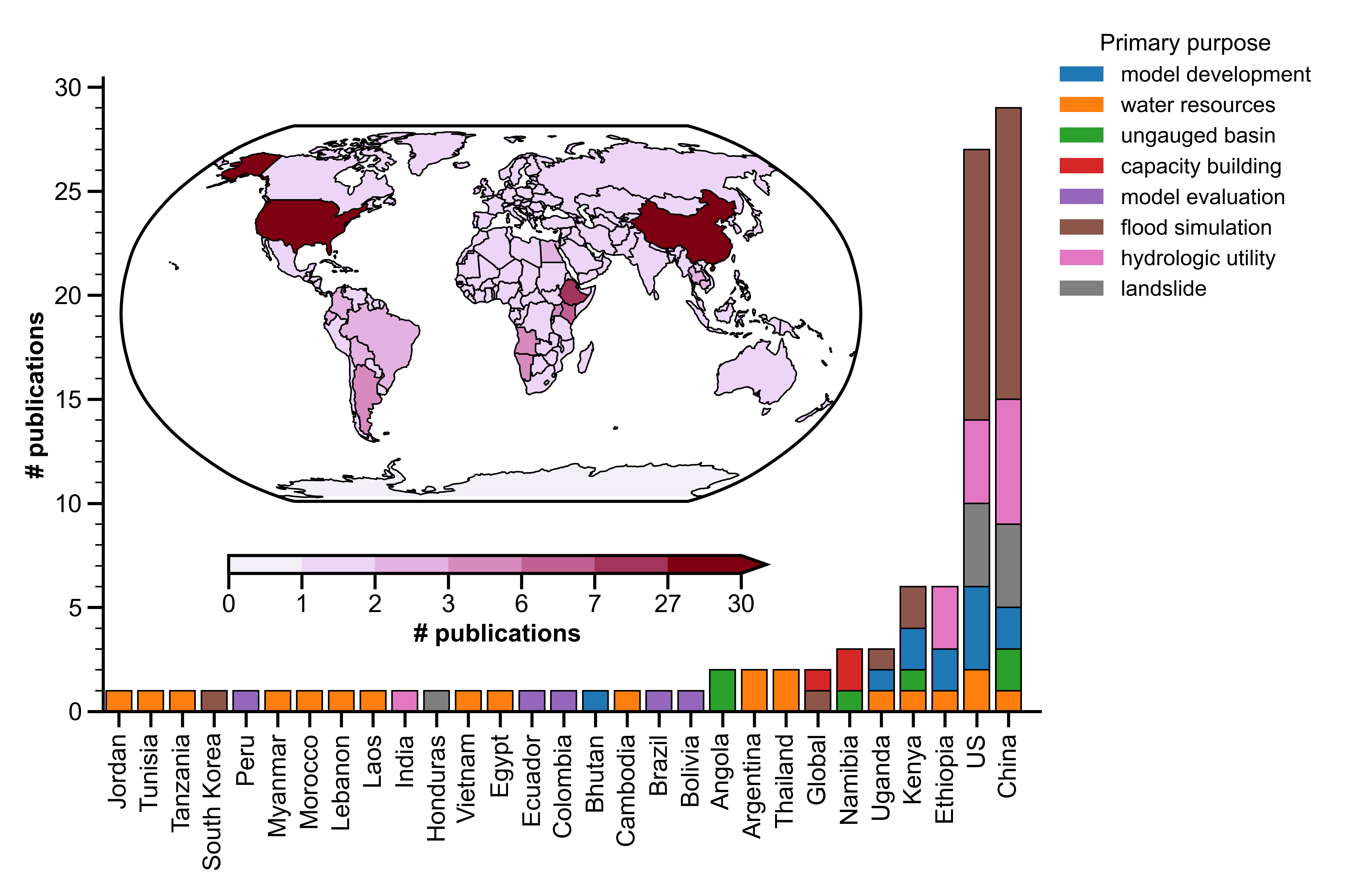
Figure 1. Map of applications per country, grouped by primary purpose.
Evaluating hydrologic utility of remote sensing precipitation products
Meng, J., Li, L., Hao, Z., Wang, J., & Shao, Q. (2014). Suitability of TRMM satellite rainfall in driving a distributed hydrological model in the source region of Yellow River. Journal of Hydrology, 509, 320-332.
Guoqiang, T. A. N. G., Zhe, L. I., Xianwu, X. U. E., Qingfang, H. U., Bin, Y. O. N. G., & Yang, H. O. N. G. (2015). A study of substitutability of TRMM remote sensing precipitation for gauge-based observation in Ganjiang River basin. Advances in Water Science, 26(3), 340-346.
Tang, G., Zeng, Z., Long, D., Guo, X., Yong, B., Zhang, W., & Hong, Y. (2016). Statistical and hydrological comparisons between TRMM and GPM level-3 products over a midlatitude basin: Is day-1 IMERG a good successor for TMPA 3B42V7?. Journal of Hydrometeorology, 17(1), 121-137.
Lakew, H. B., Moges, S. A., & Asfaw, D. H. (2017). Hydrological evaluation of satellite and reanalysis precipitation products in the Upper Blue Nile Basin: A case study of Gilgel Abbay. Hydrology, 4(3), 39.
Li, N., Tang, G., Zhao, P., Hong, Y., Gou, Y., & Yang, K. (2017). Statistical assessment and hydrological utility of the latest multi-satellite precipitation analysis IMERG in Ganjiang River basin. Atmospheric research, 183, 212-223.
Jiang, S., Zhang, Z., Huang, Y., Chen, X., & Chen, S. (2017). Evaluating the TRMM Multisatellite Precipitation Analysis for extreme precipitation and streamflow in Ganjiang River basin, China. Advances in Meteorology, 2017.
Ma, Q., Xiong, L., Liu, D., Xu, C. Y., & Guo, S. (2018). Evaluating the temporal dynamics of uncertainty contribution from satellite precipitation input in rainfall-runoff modeling using the variance decomposition method. Remote Sensing, 10(12), 1876.
Sun, W., Ma, J., Yang, G., & Li, W. (2018). Statistical and hydrological evaluations of multi-satellite precipitation products over Fujiang river basin in humid southeast China. Remote Sensing, 10(12), 1898.
Yuan, F., Wang, B., Shi, C., Cui, W., Zhao, C., Liu, Y., … & Yang, X. (2018). Evaluation of hydrological utility of IMERG Final run V05 and TMPA 3B42V7 satellite precipitation products in the Yellow River source region, China. Journal of hydrology, 567, 696-711.
Ma, Z., Tan, X., Yang, Y., Chen, X., Kan, G., Ji, X., … & Hong, Y. (2018). The first comparisons of IMERG and the downscaled results based on IMERG in hydrological utility over the Ganjiang river Basin. Water, 10(10), 1392.
Chen, M., Nabih, S., Brauer, N. S., Gao, S., Gourley, J. J., Hong, Z., … & Hong, Y. (2020). Can remote sensing technologies capture the extreme precipitation event and its cascading hydrological response? A case study of Hurricane Harvey using EF5 modeling framework. Remote Sensing, 12(3), 445.
Flood simulation and forecasting
Khan, S. I., Hong, Y., Wang, J., Yilmaz, K. K., Gourley, J. J., Adler, R. F., … & Irwin, D. (2010). Satellite remote sensing and hydrologic modeling for flood inundation mapping in Lake Victoria basin: Implications for hydrologic prediction in ungauged basins. IEEE Transactions on Geoscience and Remote Sensing, 49(1), 85-95.
Wu, H., Adler, R. F., Hong, Y., Tian, Y., & Policelli, F. (2012). Evaluation of global flood detection using satellite-based rainfall and a hydrologic model. Journal of Hydrometeorology, 13(4), 1268-1284.
Zhang, Y., Hong, Y., Wang, X., Gourley, J. J., Xue, X., Saharia, M., … & Tang, G. (2015). Hydrometeorological analysis and remote sensing of extremes: Was the July 2012 Beijing flood event detectable and predictable by global satellite observing and global weather modeling systems?. Journal of hydrometeorology, 16(1), 381-395.
Martinaitis, S. M., Gourley, J. J., Flamig, Z. L., Argyle, E. M., Clark III, R. A., Arthur, A., … & Albright, B. (2017). The HMT multi-radar multi-sensor hydro experiment. Bulletin of the American Meteorological Society, 98(2), 347-359.
Gao, Z., Long, D., Tang, G., Zeng, C., Huang, J., & Hong, Y. (2017). Assessing the potential of satellite-based precipitation estimates for flood frequency analysis in ungauged or poorly gauged tributaries of China’s Yangtze River basin. Journal of hydrology, 550, 478-496.
Gourley, J. J., Flamig, Z. L., Vergara, H., Kirstetter, P. E., Clark, R. A., Argyle, E., … & Howard, K. W. (2017). The FLASH project: Improving the tools for flash flood monitoring and prediction across the United States. Bulletin of the American Meteorological Society, 98(2), 361-372.
Gerard, A., Martinaitis, S. M., Gourley, J. J., Howard, K. W., & Zhang, J. (2021). An overview of the performance and operational applications of the MRMS and FLASH systems in recent significant urban flash flood events. Bulletin of the American Meteorological Society, 1-29.
Water resources management
Khan, S. I., Adhikari, P., Hong, Y., Vergara, H., F Adler, R., Policelli, F., … & Okello, L. (2011). Hydroclimatology of Lake Victoria region using hydrologic model and satellite remote sensing data. Hydrology and Earth System Sciences, 15(1), 107-117.
Habib, S., Kfouri, C., & Peters, M. (2012, July). Water information system platforms addressing critical societal needs in the MENA region. In 2012 IEEE International Geoscience and Remote Sensing Symposium (pp. 2767-2770). IEEE.
Rossi, M. J., & Ares, J. O. (2015). Efficiency improvement in linear-move sprinkler systems through moderate runoff–runon control. Irrigation science, 33(3), 205-219.
Rossi, M. J., & Ares, J. O. (2016). Overland flow from plant patches: Coupled effects of preferential infiltration, surface roughness and depression storage at the semiarid Patagonian Monte. Journal of Hydrology, 533, 603-614.
Gathecha, H. M. (2015). Reconstruction of streamflow into Lake Naivasha using crest model and remote sensed rainfall and evapotranspiration (Master’s thesis, University of Twente).
Ren, G., Zhan, Y., Ren, Y., Chen, Y., Wang, T., Liu, Y., & Sun, X. (2015). Spatial and temporal patterns of precipitation variability over mainland China: I: Climatology. Advances in water science, 26(3), 299-310.
Shen, X., & Anagnostou, E. N. (2017b). A framework to improve hyper-resolution hydrological simulation in snow-affected regions. Journal of hydrology, 552, 1-12.
Li, D., Zhao, J., & Govindaraju, R. S. (2019). Water benefits sharing under transboundary cooperation in the Lancang-Mekong River Basin. Journal of Hydrology, 577, 123989.
Yang, M., Wang, G., Lazin, R., Shen, X., & Anagnostou, E. (2021). Impact of planting time soil moisture on cereal crop yield in the Upper Blue Nile Basin: A novel insight towards agricultural water management. Agricultural Water Management, 243, 106430.
Hydrologic prediction in ungauged basins (PUB)
Khan, S. I., Hong, Y., Vergara, H. J., Gourley, J. J., Brakenridge, G. R., De Groeve, T., … & Yong, B. (2012). Microwave satellite data for hydrologic modeling in ungauged basins. IEEE Geoscience and Remote Sensing Letters, 9(4), 663-667.
Zhang, Y., Hong, Y., Gourley, J. J., Wang, X., Brakenridge, G. R., De Groeve, T., & Vergara, H. (2014). Impact of assimilating spaceborne microwave signals for improving hydrological prediction in ungauged basins. Remote sensing of the terrestrial water cycle, 206, 439.
Chen, X., Long, D., Hong, Y., Zeng, C., & Yan, D. (2017). Improved modeling of snow and glacier melting by a progressive two‐stage calibration strategy with GRACE and multisource data: How snow and glacier meltwater contributes to the runoff of the Upper Brahmaputra River basin?. Water Resources Research, 53(3), 2431-2466.
Han, Z., Long, D., Huang, Q., Li, X., Zhao, F., & Wang, J. (2020). Improving reservoir outflow estimation for ungauged basins using satellite observations and a hydrological model. Water Resources Research, 56(9), e2020WR027590.
Huang, Q., Long, D., Du, M., Han, Z., & Han, P. (2020). Daily continuous river discharge estimation for ungauged basins using a hydrologic model calibrated by satellite altimetry: Implications for the SWOT mission. Water Resources Research, 56(7), e2020WR027309.
Capacity building and outreach
Clark, R. A., Flamig, Z. L., Vergara, H., Hong, Y., Gourley, J. J., Mandl, D. J., … & Patterson, M. (2017). Hydrological modeling and capacity building in the Republic of Namibia. Bulletin of the American Meteorological Society, 98(8), 1697-1715.
Yami, T. L., Gao, S., Chen, M., Li, Z., Vergara, H., Clark, R. R., … & Hong, Y. (2021). CREST/EF5 capacity building to enhance resilience to hydrodynamic disasters in emerging regions. African Journal of Environmental Science and Technology, 15(6), 230-242.